Résultats des élections législatives de la commune de Saint-Vincent-Jalmoutiers:
3ème circonscription |
Code postal 24410
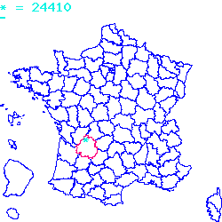
Localisé au sud-ouest de la France, le code postal 24410 est composé du numéro 24 correspondant au département Dordogne et de l'identifiant du bureau postal 410.
Le code postal 24410 appartient à 12 villes qui sont listées dans le tableau ci-dessous :
| Code postal | Ville | Code Insee |
|---|---|---|
| 24410 | Saint-Vincent-Jalmoutiers | 24511 |
| 24410 | Saint-Aulaye | 24376 |
| 24410 | Puymangou | 24343 |
| 24410 | Échourgnac | 24159 |
| 24410 | La Jemaye | 24216 |
| 24410 | Saint-Antoine-Cumond | 24368 |
| 24410 | Chenaud | 24118 |
| 24410 | Ponteyraud | 24333 |
| 24410 | Servanches | 24533 |
| 24410 | Festalemps | 24178 |
| 24410 | Parcoul | 24316 |
| 24410 | Saint-Privat-des-Prés | 24490 |

Le code postal 24410 correspond aux villes suivantes : Saint-Privat-des-Prés, Parcoul, Festalemps, Servanches, Ponteyraud, Chenaud, Saint-Antoine-Cumond, La Jemaye, Échourgnac, Puymangou, Saint-Aulaye, Saint-Vincent-Jalmoutiers. Les 12 communes sont situées dans le sud-ouest de la France dans le département Dordogne de la région de la Nouvelle-Aquitaine. Les codes INSEE, usuellement nommés codes communes, sont respectivement :
24490, 24316, 24178, 24533, 24333, 24118, 24368, 24216, 24159, 24343, 24376, 24511.
Les villes situées géographiquement près du code postal 24410 :
Chassaignes (24600), Bourg-du-Bost (24600), Petit-Bersac (24600), Nabinaud (16390), Laprade (16390), Aubeterre-sur-Dronne (16390), Bonnes (16390), Vanxains (24600), Comberanche-et-Épeluche (24600), Saint-Romain (16210), Saint-Séverin (16390).Villes proches du code postal 24410
Code postal
Ville
Superficie
Densité
Population
24600 Chassaignes 0.0579 km2 13 100 24600 Bourg-du-Bost 0.0716 km2 33 200 24600 Petit-Bersac 0.1083 km2 15 200 16390 Nabinaud 0.0588 km2 13 100 16390 Laprade 0.1017 km2 22 200 16390 Aubeterre-sur-Dronne 0.0239 km2 174 400 16390 Bonnes 0.1476 km2 25 400 24600 Vanxains 0.3589 km2 20 700 24600 Comberanche-et-Épeluche 0.0393 km2 45 200 16210 Saint-Romain 0.2269 km2 23 500 16390 Saint-Séverin 0.1493 km2 54 800 Plan et carte : Localiser le code postal 24410
Données démographiques sur le code postal 24410
1999
2010
2012
Population
Saint-Vincent-Jalmoutiers213
251
300
Densité
Saint-Vincent-Jalmoutiers1 314,00
1 548,43
1 850,71
Population
Saint-Aulaye1397
1360
1400
Densité
Saint-Aulaye4 024,78
3 918,18
4 033,42
Population
Puymangou101
94
100
Densité
Puymangou894,60
832,60
885,74
Population
Échourgnac402
416
400
Densité
Échourgnac1 152,52
1 192,66
1 146,79
Population
La Jemaye104
108
100
Densité
La Jemaye357,14
370,88
343,41
Population
Saint-Antoine-Cumond364
390
400
Densité
Saint-Antoine-Cumond2 998,35
3 212,52
3 294,89
Population
Chenaud321
319
300
Densité
Chenaud2 551,67
2 535,77
2 384,74
Population
Ponteyraud31
53
100
Densité
Ponteyraud739,86
1 264,92
2 386,63
Population
Servanches103
80
100
Densité
Servanches500,97
389,11
486,38
Population
Festalemps243
254
200
Densité
Festalemps1 980,44
2 070,09
1 629,99
Population
Parcoul411
375
400
Densité
Parcoul2 900,49
2 646,44
2 822,87
Population
Saint-Privat-des-Prés617
579
600
Densité
Saint-Privat-des-Prés3 143,15
2 949,57
3 056,55
Données géographiques se rapportant au code postal 24410
Nom et code commune
Superficie
Longitude
Latitude
Saint-Vincent-Jalmoutiers
245110.1621
0.183333
45.2
Saint-Aulaye
243760.3471
0.133333
45.2
Puymangou
243430.1129
0.083333
45.2
Échourgnac
241590.3488
0.233333
45.1167
La Jemaye
242160.2912
0.25
45.1667
Saint-Antoine-Cumond
243680.1214
0.2
45.2667
Chenaud
241180.1258
0.1
45.2167
Ponteyraud
243330.0419
0.233333
45.2
Servanches
245330.2056
0.166667
45.15
Festalemps
241780.1227
0.233333
45.2333
Parcoul
243160.1417
0.033333
45.2
Saint-Privat-des-Prés
244900.1963
0.216667
45.2333
Météo à Saint-Vincent-Jalmoutiers / 24410


 Mairie Saint-Vincent-Jalmoutiers
  Villes voisines au 24410
 Carte et plan 24410