Résultats des élections législatives de la commune de Groseillers:
1ère circonscription |
Code postal 79220
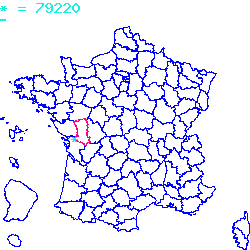
Localisé au sud-ouest de la France, le code postal 79220 est composé du numéro 79 correspondant au département Deux-Sèvres et de l'identifiant du bureau postal 220.
Le code postal 79220 appartient à 10 villes qui sont listées dans le tableau ci-dessous :
| Code postal | Ville | Code Insee |
|---|---|---|
| 79220 | Groseillers | 79139 |
| 79220 | Saint-Christophe-sur-Roc | 79241 |
| 79220 | Xaintray | 79357 |
| 79220 | Sainte-Ouenne | 79284 |
| 79220 | Surin | 79320 |
| 79220 | La Chapelle-Bâton | 79070 |
| 79220 | Pamplie | 79200 |
| 79220 | Germond-Rouvre | 79133 |
| 79220 | Cours | 79104 |
| 79220 | Champdeniers-Saint-Denis | 79066 |

Le code postal 79220 correspond aux villes suivantes : Champdeniers-Saint-Denis, Cours, Germond-Rouvre, Pamplie, La Chapelle-Bâton, Surin, Sainte-Ouenne, Xaintray, Saint-Christophe-sur-Roc, Groseillers. Les 10 communes sont situées dans le sud-ouest de la France dans le département Deux-Sèvres de la région de la Nouvelle-Aquitaine. Les codes INSEE, usuellement nommés codes communes, sont respectivement :
79066, 79104, 79133, 79200, 79070, 79320, 79284, 79357, 79241, 79139.
Les villes situées géographiquement près du code postal 79220 :
Saint-Marc-la-Lande (79310), Cherveux (79410), Le Retail (79130), La Boissière-en-Gâtine (79310), Béceleuf (79160), Échiré (79410), Mazières-en-Gâtine (79310), Allonne (79130), Fenioux (79160), Saint-Gelais (79410), Saint-Maxire (79410).Villes proches du code postal 79220
Code postal
Ville
Superficie
Densité
Population
79310 Saint-Marc-la-Lande 0.1022 km2 35 400 79410 Cherveux 0.2225 km2 74 1600 79130 Le Retail 0.1445 km2 18 300 79310 La Boissière-en-Gâtine 0.1098 km2 20 200 79160 Béceleuf 0.1904 km2 36 700 79410 Échiré 0.3096 km2 107 3300 79310 Mazières-en-Gâtine 0.1906 km2 50 1000 79130 Allonne 0.2298 km2 28 600 79160 Fenioux 0.3365 km2 20 700 79410 Saint-Gelais 0.164 km2 106 1700 79410 Saint-Maxire 0.1441 km2 78 1100 Plan et carte : Localiser le code postal 79220
Données démographiques sur le code postal 79220
1999
2010
2012
Population
Groseillers73
67
100
Densité
Groseillers1 636,77
1 502,24
2 242,15
Population
Saint-Christophe-sur-Roc453
593
600
Densité
Saint-Christophe-sur-Roc4 133,21
5 410,58
5 474,45
Population
Xaintray199
240
200
Densité
Xaintray1 784,75
2 152,47
1 793,72
Population
Sainte-Ouenne569
788
700
Densité
Sainte-Ouenne4 913,64
6 804,84
6 044,91
Population
Surin515
610
600
Densité
Surin3 783,98
4 482,00
4 408,52
Population
La Chapelle-Bâton318
381
300
Densité
La Chapelle-Bâton1 878,32
2 250,44
1 772,00
Population
Pamplie271
273
300
Densité
Pamplie2 205,04
2 221,32
2 441,01
Population
Germond-Rouvre880
1152
1100
Densité
Germond-Rouvre4 921,70
6 442,95
6 152,13
Population
Cours414
541
500
Densité
Cours2 774,80
3 626,01
3 351,21
Population
Champdeniers-Saint-Denis1491
1675
1600
Densité
Champdeniers-Saint-Denis6 836,31
7 679,96
7 336,08
Données géographiques se rapportant au code postal 79220
Nom et code commune
Superficie
Longitude
Latitude
Groseillers
791390.0446
-0.4
46.5333
Saint-Christophe-sur-Roc
792410.1096
-0.35
46.45
Xaintray
793570.1115
-0.466667
46.5
Sainte-Ouenne
792840.1158
-0.45
46.45
Surin
793200.1361
-0.463611
46.4606
La Chapelle-Bâton
790700.1693
-0.329444
46.4737
Pamplie
792000.1229
-0.433333
46.5333
Germond-Rouvre
791330.1788
-0.420278
46.455
Cours
791040.1492
-0.416667
46.5
Champdeniers-Saint-Denis
790660.2181
-0.405
46.4842
Météo à Groseillers / 79220


 Mairie Groseillers
  Villes voisines au 79220
 Carte et plan 79220